28 Aug What’s the hurricane forecast this year?

Last year, Maine and New Hampshire escaped serious damage during the hurricane season (June 1 – November 30), nevertheless, government agencies say there were 19 tropical storms, 10 of which became hurricanes in the North Atlantic. The most notorious was Superstorm Sandy that caused 200 deaths and more than $60 billion in damage when it slammed into the mid-Atlantic states as it was accompanied by a devastating storm surge that caused extraordinary flooding.
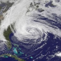
(This photo from NOAA / NASA shows Superstorn Sandy heading up the Atlantic coast)
What’s being predicted for hurricanes this year? The National Oceanic and Atmospheric Administration (NOAA) predicted in May an “active or extremely active” hurricane season for this year (13 to 20 named storms with 7 to 11 of those reaching hurricane status).
Their report was based on the following factors:
- A continuation of the atmospheric climate pattern, which includes a strong west African monsoon, that is responsible for the ongoing era of high activity for Atlantic hurricanes that began in 1995;
- Warmer-than-average water temperatures in the tropical Atlantic Ocean and Caribbean Sea; and
- El Niño is not expected to develop and suppress hurricane formation.
Their Climate Prediction Center, however, trimmed its forecast in early August to 13 to 19 named storms with 6 to 9 reaching hurricane status, five of which could be Category 3 storms (sustained winds greater than 111 mph).
Being prepared now may provide peace of mind should a hurricane make its way to Maine and New Hampshire. Update your hurricane plan by visiting www.ready.gov/hurricanes. ”Also, click here to learn more about flood insurance.
The models do not predict if these storms will make landfall. However, once a storm forms, NOAA’s National Hurricane Center will issue regular updates. This federal agency is employing new and powerful computer modeling that could improve forecast accuracy by 10 to 15 percent.
According to Independent Agent Magazine, a newly released hurricane predictive model for the North Atlantic Ocean says the threat of a hurricane-driven storm surge has “a 20% chance that storm surge losses will be greater than wind losses for any U.S. hurricane that makes landfall this season, rising to more than 30% in the Northeast. ”That is troubling when the CoreLogic Storm Surge Report “estimated that more than 4.2 million homes along the Atlantic and Gulf coasts are located within storm-surge risk zones. According to the report, that amounts to up to $1.1 trillion in property exposure.”
The article also notes that ongoing costs for damage to businesses are a big factor because many policies cover not simply replacement of business assets but business interruption. The business income coverage forms address the lost income of a business whose income is slowed down or ceases operations as a result of a covered peril such as wind damage.Business income includes net income that would have been earned if the loss had not occurred and the cost of continuing normal operations including payroll.
As we near the first anniversary of Superstorm Sandy, it is important for us in Maine and New Hampshire to understand where and how a hurricane and storm surge could impact us. Here are some questions and answers about hurricanes.
Q: What is a hurricane?
A: A hurricane is a category of tropical cyclone, the general term for all circulating weather systems (counterclockwise is the Northern Hemisphere) over tropical waters with a well defined circulation and maximum sustained winds of 74 mph (64 knots) or higher.
Q: What is a storm surge?
A: Again,according to IA Magazine, “Storm surge arises from a hurricane’s combination of high winds and low pressure, which works to accumulate water within the storm as it crosses the ocean. When it reaches shore, the hurricane releases the amassed water as a powerful rush over land.”
Q: How far inland can storm surge be animmediate problem?
A: According to NOAA, “it depends on how quickly the terrain rises along your shore. If it is a very low, flat area (like near a river basin), the storm surge would obviously reach a lot further inland than when it runs up against a steeply sloping shoreline. It doesn’t act exactly like a tidal wave, but is a big dome of water perhaps 20 feet or so high. The exact height of a storm surge depends upon so many factors: the strength of the hurricane, how quickly the hurricane is moving, what direction it is moving relative to the shoreline (is it coming straight in, or grazing along an angle?), how rapidly the sea floor is sloping along the shore,the shape of the shoreline, and the astronomical tide. Anything along the shore which isn’t higher than the depth of the storm tide is at risk, which could be many miles in a very flat area. Also keep in mind that the height of the storm surge does NOT include the high of the waves on top of it.”
Q: What kind of risk do we have in Maine?
A: Though wind causes the most frequent damage, properties in low-lying coastal areas are prone to flooding. The Federal Emergency Management Administration (FEMA) recently has redrawn their flood zone maps which could drastically alter the associated cost for federal flood insurance. Generally, properties south of Portland are likely to be at greater risk of flooding given lower elevations than the more rock-bound coastline North of Portland. Interestingly, inland properties along rivers and streams also are subject to the changes and associated insurance costs. We’ll have more information about flood insurance in future editions.


